 |
|
|
|
|
|
|
|
|
|
|
|
|
|
Dirt Roads and Side Trips in ColoradoFor the most part, this website has focused on paved roads that anyone on a street bike would feel comfortable riding. That has left out a lot of good roads that are unpaved but still no problem to ride, and well worth doing so. This page is devoted to those. Part of the impetus for this page comes from Larry Matkovich, who
runs Larry's Custom Cycle in Canon City. Larry has offered to send me information
on “dirty” roads, and he has developed a rating system for them. Here's
what he says: “I’ll be sending info on some dirty roads, as I have
extra time. I will give a rating of 0-5 meaning in good weather with dry conditions.
Most require state tags but some are open to OHV. I will probably not send any
rated 4 or 5, and very few 3.” If you would like to provide information for other roads to add here please do. And if you do send in a road, please rate it as per Larry’s system. Click on the maps and photos below for a larger version. Click again then on the larger images to close them. Shelf Road, Rating 2
Take Raynolds Avenue North from US 50 to Pear. Take Pear one block west to Field Avenue. Turn North on Field Avenue (you will stay on this road until Cripple Creek, but the name will change). You will go about 10 miles on the pavement before reaching gravel. There are a few points of interest on both sides of road (also a Colorado DOW shooting range). Also check out Red Canyon Park. After reaching the gravel you are on Shelf Road. This is a one-lane road that is cut into the side of a mountain, (originally a stage coach route) about 300 feet above the valley. There is some good scenery and wildlife viewing. (I have seen bear, mountain lion, deer, elk, and big horn sheep.) Warning: Road maintenance is sparse. In spring the road may flood (one river crossing) and may still be snowpacked in spots until May or June. Mud may be bad. Check locally (Canon City Chamber, 719-275-2331, is located in Wal Mart parking lot, Fremont County Sheriff, 719-275-5555, usually has local road conditions).
Apishapa Pass, Rating 2
From Cuchara take CO 12 South past the ski area to the top of Cuchara Pass. Turn east on the dirt road (USFS 415, but may also have a Huerfano county number). This road changes number several times but if you stay on the main road at all intersections you should arrive in Aguilar. This road passes through some scenic mountain areas just south of the Spanish Peaks Wilderness Area (trail head and parking) and just north of the Spanish Peaks Wildlife Refuge. I have seen deer, elk, small game, fowl, and birds of prey. Eagles and hawks are here but rarely seen! Should also be bobcat, lion, and bear in area. Poisonous reptiles include rattlesnakes and gila monsters (endangered species). Warning: No winter road maintenance. Road may be impassable due to snow as late as May or June. Fire regulations may be in effect. Call for road conditions: Huerfano
County: Chamber 719.738.1065, Sheriff 719.738.1600 Land's End Road, Rating 2Turn off CO 65 at the 31 mile marker on top of Grand Mesa, running down to U.S. 50 near Whitewater - approximately 21 miles. Utterly spectacular. After turning off CO 65 the Land's End Road runs along the edge of the mesa a ways until it goes over the edge. Then you're looking at switchbacks galore, vistas that do not stop, and an absolutely fabulous ride. On top of the mesa the road alternates between pavement and good gravel. Once you go over the edge it's all gravel until you get near U.S. 50 at the bottom. Just take your time and enjoy. You'll find more about this road in my blog, here. Boreas Pass, Rating 1
Just south of where CO 9 now diverges from Main St. going through Breckenridge there is a turn-off that is not marked for Boreas Pass, but is marked for Rotary Snowplow Park. That is Boreas Pass Road. The road is paved as it sweeps up the hill above Breckenridge but soon gets narrow and turns to gravel. As a gravel road it is decent, with some washboard and some potholes. It's actually slower going for a car than a motorcycle because a bike can weave in and around the potholes. While it's a very easy ride on any bike, there are spots that look like they would be pretty unpleasant in wet conditions. At the top of the pass there are some railroad buildings that survive from the time when there was a town up there. These are worth a stop. Heading down the other side, at least in the summer of 2011, the road is in extremely good condition, seeming to have been nicely graded very recently. It's only when you get down very close to Como that it starts getting a little rougher again, presumably due to heavier use down there. And coming down there are some fabulous, sweeping views of South Park. Enjoy. Kebler Pass, Rating 0
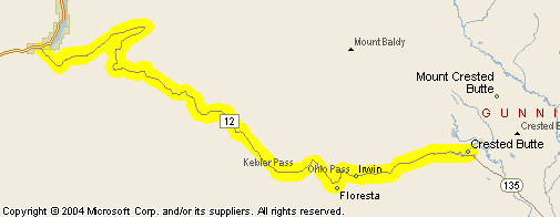
Gunnison County Road 12 intersects CO 133 coming down off McClure Pass between Carbondale and Hotchkiss. According to Andy Simons, who sent me these photos, it is a “dirt road but suitable for all bikes (well-graded and packed).” Just to check, I did a web search and found another site where they described this road as “suitable for any vehicles.” Elsewhere, any comments I found said it was fabulous. I finally took this road myself in 2009 and can confirm that it is very passable on any street bike. Click on the photos to enlarge them. Don’t bother clicking on the map; unlike the others on this page it does not enlarge because there's no need. I’ve also added additional Kebler Pass on the Crested Butte page.
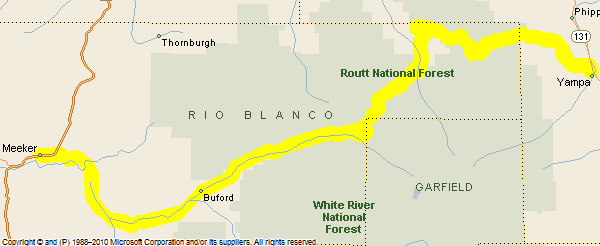
Ripple Creek Pass, Rating 2
Ripple Creek Pass, between either Yampa or Phippsburg on the east and Meeker on the west, is a gorgeous ride but parts of the road are pretty rough. We did it on regular street bikes but were somewhat regretful that we had. So I'm rating it a 2. But it's such a terrific road if you're on the right bike that I gave it its own page. |
| |


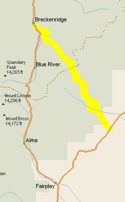 (Boreas Pass Road, Park County Road 33), Breckenridge to Como and U.S. 285 – approximately 18 miles.