 |
|
|
|
|
|
|
|
|
|
|
|
|
|
Cottonwood Pass and Taylor Canyon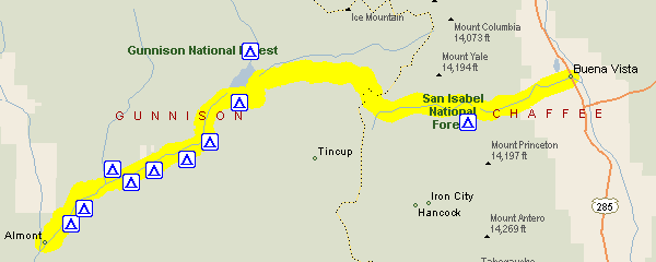
Taylor Canyon and Cottonwood Pass are really two separate stretches of road but one leads to the other, so it makes sense to consider them together. Whereas normally I'd be calling this route by some name, such as "CO 38," that doesn't work along here. Heading west out of Buena Vista toward Cottonwood Pass, you'll be more or less on Chaffee Country Road 321. Once over the top you'll be on Gunnison County Road 209. That takes you down to Taylor Reservoir, where you'll get onto Gunnison County Road 742 going down Taylor Canyon. The road comes out to CO 135 at the small town of Almont, which is 10 miles north of Gunnison and 17 miles south of Crested Butte. Let's go west to east describing this route. You'll head east from Almont and quickly find yourself in some very beautiful country. Taylor Canyon is narrow and steep and heavily wooded. Campground abound along this road, as you can see on the map, and nearly all of them are motorcycle-accessible, due largely to the fact that in the narrow canyon nothing is far from the road. The campgrounds in the canyon, in order, are Gunnison Mountain Park, Granite, North Bank, Rosy Lane, Lodgepole, Cold Spring, and Lottis Creek. Here are some photos from Taylor Canyon. The last three are the dam forming Taylor Reservoir, looking downstream from the top of the dam, and the reservoir itself. Click on the thumbnails to view the larger images. 


You come up out of Taylor Canyon into a bowl, where you find Taylor Reservoir. This is a very popular recreation spot and swarms with boaters. There are numerous cabins and other places to stay, as well as restaurants. Before the pavement ends you pass a paved turn-off that goes up the hillside to Lakeview Campground, which is very large and very busy. Leaving the pavement a little later, the road curves around the lake to Rivers End Campground. This is a fisherman's campground with no trees or natural shelter. It is motorcycle-accessible, however. The road heading up Cottonwood Pass splits off before you would get to Rivers End. It winds languidly up the mountain, with numerous switchbacks and a lot of terrific viewpoints. At the top of the pass you can park and climb up to the top of the neighboring peaks, or just up on the ridge, from which you can see the descending road winding away on either side of the pass. The east side of the pass has its own share of switchbacks and is worth a ride if all you do is come up and it go back down. There is one motorcycle-accessible campground along this stretch, Collegiate Peaks. Further down you'll come across the Cottonwood Hot Springs Inn & Spa, which is a very nice place to end a day of riding. They have individual cabins, hotel-type rooms, and even communal bunkhouse rooms for both sexes. From there, Buena Vista is just 5 miles away, with plenty of restaurants and motels. Here are some photos from Cottonwood Pass, five on the west side, one on top, and one on the east side. 


|
|
|