Part of an Eight-Day Trip from Atlanta to ColoradoContributed
by Paul Hall-Smith 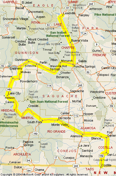 Day
5 – Reaching Colorado Day
5 – Reaching Colorado
The ride north towards Colorado is through
some amazing scenery. The southern tip of the Rockies slowly rear skywards as
I speed along Highway 159 from the New Mexico state line. In Fort Garland I feel
as if I could reach out and touch Blanca Peak. I turn westward once more passing
through South Fork. The road follows the Rio Grande River valley through some
of the most spectacular scenery I have ever seen. At Slumguillion
Pass, 11,361 feet, I cross over the Continental Divide and am able to look
back at the Rio Grande headwaters and the San Juan mountains. The 75-mile-long
section of this road between South Fork and Lake City (most expensive gas of the
trip at $1.79) is known as the Silver Thread Byway. The entire length of
this road is highly scenic. The southern section passes through typical Colorado
ranching country, while the northernmost part is through more arid country. In
Gunnison I turn eastwards and then north on 285
to Leadville. Passing over Monarch Pass, 11,312
feet, I cross the Continental Divide once more. Arriving in Leadville, at 10,200
feet North America's highest incorporated city, I have traveled about 392 miles. Unpacking
after a 392-mile ride I make my way to the Silver Dollar Saloon and quickly find
out that alcohol and altitude work well together? After four libations I call
it a night. Tomorrow I will ride to the top of Mt. Evans. The main reason for
the trip. Day 6 – Mt. EvansRising early the weather is fine
and clear with cloudless blue skies. Bud, the motel owner, tells me the trip from
the Treeline Motel; bike friendly, to the entrance to Mt. Evans State Park is
about 1 hour 40 minutes. One hour 15 minutes later I arrive after a great morning
ride. The Eisenhower Tunnel on I-70 is a strange green fluorescent hole bored
through the mountain. The speed limit on the road
to the summit of Mt. Evans is posted at 30 mph. Due to the higher elevation,
that's the speed I keep at in 3rd gear. The road to the summit affords spectacular
views at every turn. The tree line is so clearly delineated it’s as if someone
had taken a giant weed eater and removed all the trees from the summit down to
the tree line in one fell swoop. The weather is perfect all the way to the summit.
Clear blue skies. 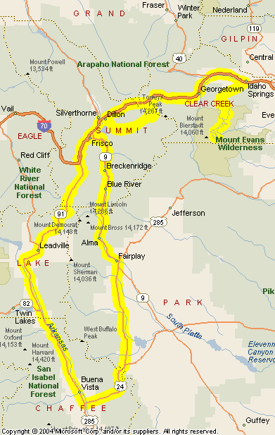
Hardier souls than me are walking, running, or cycling to the top. At
the summit I find one male who is sitting cross-legged on a bench meditating and
two females who are preparing to walk up the last 150 feet or so of elevation.
I realize as soon as I stop that I will not be making this relatively short walk.
The thinner air at 14,260 feet has me breathing deep and hard. The views
leave me completely breathless. Stunning vistas for 360 degrees. Looking down
at lower peaks is really quite difficult to comprehend. This is now the highest
I have ever been with my two feet planted firmly on the ground. I am in
awe at the sweep of the landscape below me. The bighorn sheep are close by and
the few of us there keep a wary eye on them. Don’t want to be featured on
the next “When wild animals go bad” video. More people are arriving
and I am pleased I chose to make an early start so as to have a few moments of
quiet reflection whilst I look out at the mountain ranges and wide open spaces
below me. Soon the newcomers are out of the cars brandishing cameras, hassling
the bighorn sheep that have the good sense to make a slow dignified retreat. One
lady walks after them whilst clutching her little yapping dog. She seems surprised
that the bighorns keep moving away. I wish she would put the dog on the ground
so that the bighorns could take care of it. A couple of the cyclists appear,
completely at ease in this rarefied air. It has taken them 2 hours and 55 minutes
to make the 15-mile climb. They are practicing for an upcoming race during which
they expect their time to be reduced to 2 hours and 30 minutes. When I ask how
they cannot be out of breath they reply with a smile “Pacing that's all,
pacing.” Yeah right, I think – freaks. The ride down the mountain
is bedeviled by more cars whose drivers are more intent on looking at the scenery
than oncoming traffic. The Kisan headlight modulator catches their attention and
saves me from being knocked off the road into space. The return journey
on I-70 leaves me craving more height so I turn off before the Eisenhower Tunnel
and ride up over the Loveland Pass at 11,982 feet.
I descend through more spectacular scenery riding through the summer/winter resort
of Keystone. Back onto I-70 for a few more miles and then south making a loop
through Breckenridge over Hoosier Pass at 11,541
feet. Returning to Leadville I have traveled about 243 miles. Day 7 –
Turning Toward Home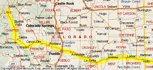
Having slept badly at the 10,200-foot altitude for two nights I decide to leave
Leadville. The threat of tropical storm Claudette is showing itself on the long-range
radar and my return home could be a wet one and this also hastens my early departure
from Colorado. I will not be returning through Okalahoma and decide to cross Kansas
in the hope it will be a less windy route.
The ride from Leadville south
to Canon City and Pueblo takes me alongside the Arkansas
River. Plenty of twistys to satisfy any biker with ample passing places to
enable me to keep up a good speed. From Pueblo eastwards Highway 50 is straight,
flat, and mercifully relatively windless. At a gas station east of Pueblo I speak
with a sports bike rider who had left Denver that morning heading for Virginia.
He tells me that riding his bike for the distance he had is making him older.
I suggest he test ride a Valkyrie and his response, whilst not rude, is less than
willing. I’m back on the road before him but he soon passes me at over 100
mph. I tuck in behind him to show that a sports cruiser can make pace. After a
couple of miles I reduce speed to save any possible license damage. Some 50 miles
further on I pass a gas station where the sports bike rider is off his bike trying
to stretch out. I give him a blast on the horn and a few minutes later he passes
me once more at a high rate of speed. Some 50 miles later I stop to refuel and
he’s there again. This continues for the next 200 miles. The temperature
as we cross Kansas increases to a maximum of 104F. Every gas stop I am drinking
at least 16 oz of water. So much fluid in and not one restroom stop. Back
to top |